Outdoor lovers love Woodstock! Bring a love for adventure and set out on a multitude of trails that Woodstock, GA has to offer. With different difficulty levels, anyone can enjoy the terrain, green views and crisp, fresh air.
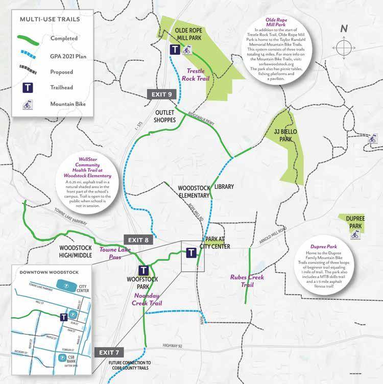
Woodstock’s Olde Rope Mill Park is known for its variety of hiking and biking trails, kayaking, fishing, and other outdoor activities. Woodstock is also home to the Greenprints Trail System, a series of multi-use trails developed by the Greenprints Alliance in conjunction with the City of Woodstock. In total 60+ miles of trails and green spaces make up the Greenprints plan. Favorite trails include Noonday Creek Trail which is 1.43 miles long beginning at Market Street in Downtown and continuing along Noonday Creek passing the bridge to Woofstock Park dog park along the Way. Towne Lake Pass at 1.2 miles long is another popular choice that runs along the creek and connects to Towne Lake Parkway as is the Rubes Creek Trails at 1 mile long. Below is a map that shows the trail intersections in proximity to downtown Woodstock.
WoodstockTrailMap (Greenprints Trail Map)
Hiking is the perfect activity to catch up with a friend, begin an active lifestyle, or enjoy free no-screen family time without distractions! Interested in coming home to Woodstock? Check out Tuscany Village by Kittle Homes – a luxury gated townhome communities just minutes from Downtown and your gateway to the outdoors!

